A development promise cuts through a living climate asset
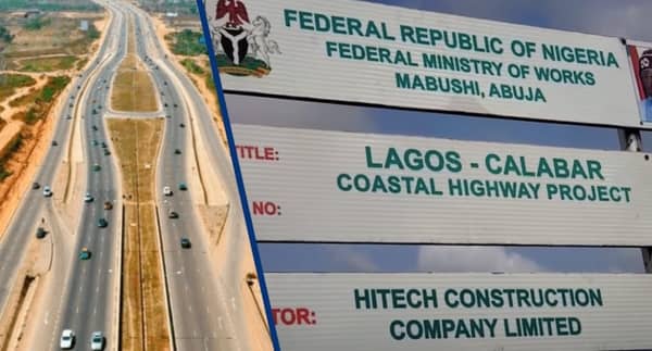
Nigeria’s plan to build the Lagos–Calabar Coastal Highway is framed as a statement of ambition. Stretching along the country’s southern coastline, the proposed road is designed to improve transport efficiency, open up coastal economies, and link commercial centres across multiple states. For policymakers, it represents movement, speed, and growth.
But along the planned route in Akwa Ibom State, the highway intersects with Stubbs Creek Forest Reserve, one of the Niger Delta’s remaining rainforest ecosystems. A new scientific assessment shows that routing the highway through this reserve would do more than clear land. It would dismantle a functioning climate system and replace it with a long-term source of greenhouse gas emissions.
The assessment, conducted by Joel Emmanuel Benson, a greenhouse gas scientist and analyst, quantifies the climate impact of the highway using greenhouse gas flux analysis. Drawing on remote sensing data, geospatial datasets, and established carbon accounting methods, the study concludes that the project would release more than 3.5 million tonnes of carbon dioxide equivalent into the atmosphere and erase the forest’s future ability to absorb carbon.
The findings place Nigeria’s development choices into sharp focus, not as an abstract debate between growth and conservation, but as a measurable trade-off with lasting consequences for climate stability, livelihoods, and national resilience.
A forest that regulates climate, not just land
Stubbs Creek Forest Reserve was gazetted in 1930 as a protected area during the colonial era. Located in southern Akwa Ibom State, it spans parts of Ibeno, Esit Eket, Eket, and Mbo local government areas. The reserve sits within the Niger Delta, a region defined by wetlands, mangroves, swamp forests, and some of Nigeria’s most climate-sensitive landscapes.
The forest lies in a tropical wet climate zone, receiving between 1,700 and over 4,000 millimetres of rainfall annually, with average temperatures ranging from 25 to 28 degrees Celsius. These conditions support dense rainforest vegetation and soils rich in organic carbon. According to international soil databases referenced in the study, the reserve’s low-activity clay soils store an estimated 52 tonnes of carbon per hectare.
This capacity makes Stubbs Creek more than a protected forest on paper. It functions as a carbon sink, absorbing carbon dioxide from the atmosphere through photosynthesis and storing it in tree biomass and soil. In doing so, it slows the accumulation of greenhouse gases and helps regulate both local and global climate.
“Forests like Stubbs Creek are not passive landscapes,” Benson said in the report. “They actively regulate climate by storing carbon and maintaining ecological balance. Once disturbed, that function is reversed.”
A reserve already under pressure
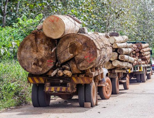
Stubbs Creek has not been insulated from decades of human activity. Oil production, fuelwood harvesting, farming, and illegal logging have steadily reduced forest cover. Data cited in the assessment show that dense forest area declined from 63.5 square kilometres in 1993 to 28.22 square kilometres by 2013. Earlier projections suggested that, without intervention, the reserve could disappear entirely within decades.
Against this backdrop, the planned highway represents a decisive turning point. Rather than slowing forest loss, it would formalise and accelerate it.
To reflect present realities, Benson’s study adopted the 2013 dense forest area of 28.22 square kilometres as the baseline for analysis. The assessment models emissions over a 20-year period, combining a one-year implementation phase, when forest clearing and construction occur, with a 19-year capitalisation phase that captures ongoing carbon losses from soil disturbance, biomass decomposition, and secondary pressures such as increased access and edge effects.
Measuring emissions beyond the construction phase
Public debates around infrastructure projects in Nigeria often centre on visible impacts such as land acquisition, compensation, or biodiversity loss. What distinguishes this study is its focus on greenhouse gas fluxes, expressed in concrete numbers.
Using the Environmental Externalities Accounting Framework, the analysis estimates a total carbon balance of 3,511,562 tonnes of carbon dioxide equivalent associated with the highway route through Stubbs Creek. This represents a net release of greenhouse gases into the atmosphere.
Carbon dioxide dominates the emissions profile, accounting for 3,510,847 tonnes of carbon dioxide equivalent. Most of this comes from the removal of forest biomass and the loss of soil carbon once vegetation is cleared and soils are disturbed. Nitrous oxide, a greenhouse gas with a global warming potential 265 times greater than carbon dioxide over a 100-year period, contributes an additional 715 tonnes of carbon dioxide equivalent.
“Nitrous oxide emissions rise sharply when tropical forests are cleared,” the report notes. “The disruption of nitrogen cycling in forest soils creates conditions that favour microbial processes that release N₂O.”
Under intact forest conditions, nitrogen is largely stored in living biomass and stable soil pools. Clearing the forest releases this nitrogen, increasing emissions in a region already characterised by wet soils and high rainfall.
The combined effect, Benson writes, is a conversion of Stubbs Creek from a carbon sink into “a significant carbon source,” with the loss extending beyond existing carbon stocks to include future sequestration capacity.
Putting a price on lost climate services
Beyond emissions figures, the study assigns an economic value to the climate impact of the proposed highway route. Applying a carbon price of 158 US dollars per tonne of carbon dioxide equivalent, the total emissions are valued at approximately 554.8 million dollars.
Converted using the Central Bank of Nigeria’s exchange rate in late January 2026, this amounts to about 785 billion naira.
This valuation does not represent construction costs or compensation payments. It reflects the climate services the forest provides by storing carbon and reducing future climate risks.
“The economic cost captures what is often invisible in infrastructure planning,” Benson said. “When forests are cleared, society absorbs the climate damage over time, through increased vulnerability, adaptation costs, and loss of ecosystem services.”
For the Niger Delta, those services are closely tied to survival. The region’s low-lying geography makes it vulnerable to flooding, storm surges, and sea-level rise. Forests and wetlands act as natural buffers, stabilising soils, regulating water flow, and moderating extreme weather impacts.
Removing Stubbs Creek weakens that natural defence at a time when climate extremes are intensifying.
Development corridors and climate blind spots
The Lagos–Calabar Coastal Highway is part of a broader push to expand Nigeria’s transport infrastructure and unlock coastal development. Supporters argue that improved roads will stimulate trade, tourism, and investment along the southern corridor.
The study does not dispute these economic objectives. Instead, it highlights a gap in how such projects are assessed.
“Financial and social benefits are routinely quantified,” the report states. “Climate costs are rarely evaluated with the same level of rigour.”
By excluding greenhouse gas emissions from project appraisal, infrastructure decisions risk underestimating long-term costs. In this case, the emissions from a single forest reserve rival those of entire industrial sectors over similar timeframes.
The implications extend beyond Akwa Ibom State. Africa is warming faster than historical averages, with rising concentrations of carbon dioxide, methane, and nitrous oxide driving heatwaves, droughts, and shifting rainfall patterns, according to recent global climate assessments cited in the study.
In this context, the loss of a major forest carbon reservoir carries regional and global significance.
A climate asset with national relevance
The study positions Stubbs Creek Forest Reserve as a strategic climate asset. Its value lies not only in biodiversity or conservation status, but in its contribution to climate mitigation.
“The protection of Stubbs Creek is non-negotiable from a climate perspective,” Benson concluded. “Once lost, the carbon storage and sequestration functions cannot be easily restored.”
The report recommends rerouting the highway well away from the reserve and suspending all construction activities within or near its boundaries. It also calls for the integration of comprehensive climate impact assessments into infrastructure planning, particularly for road projects in forested regions.
Other recommendations include the formal recognition of forest reserves as climate assets within national development frameworks, the establishment of a dedicated and well-resourced management authority for Stubbs Creek, and long-term conservation programmes supported by national and international partners.
Choices that shape the future
Nigeria’s infrastructure needs are real, as are demands for mobility, jobs, and economic growth. The question raised by the Stubbs Creek assessment is not whether development should happen, but how it is designed and what costs are acknowledged.
Climate impacts do not appear immediately in project timelines, but they accumulate steadily, shaping flood risks, food systems, and public health outcomes over decades.
By quantifying emissions and economic costs, the study offers policymakers a clearer picture of what is at stake. It also leaves room for alternative decisions.
Rerouting the highway, strengthening forest protection, and embedding climate accounting into development planning would allow Nigeria to pursue infrastructure expansion without sacrificing a critical climate asset.
As the country charts its development path, the fate of Stubbs Creek Forest Reserve stands as a test case of whether growth can proceed with full awareness of its climate consequences, and whether choices made today can still preserve options for tomorrow.